SDRF Is Doing Drone Surveillance in the Flood-Affected Kheer Ganga Ghat in Dharali; Relief and Logistics Affected Due to Road Closure”
Introduction
SDRF In early August 2025, the serene locale of Dharali in Uttarkashi, nestled along the Kheer Ganga stream, faced catastrophic devastation. A powerful cloudburst triggered a flash flood that roared down the slopes, sweeping away homes, hotels, roads, and businesses. In the aftermath, rescue and relief operations have transformed into a high-stakes humanitarian mission, with modern technology and disaster-response teams mobilized under intense pressure.
At the heart of this ongoing operation stands the State Disaster Response Force (SDRF), deploying drone surveillance over the ravaged Kheer Ganga Ghat. But why this specific strategy? What are the challenges in relief and logistics? This blog unpacks the complexities, explores how SDRF’s drone deployment is reshaping rescue efforts, and lays out the broader environmental, administrative, and human dimensions of this ordeal.
1. The Disaster Strikes: Cloudburst and Flash Floods SDRF
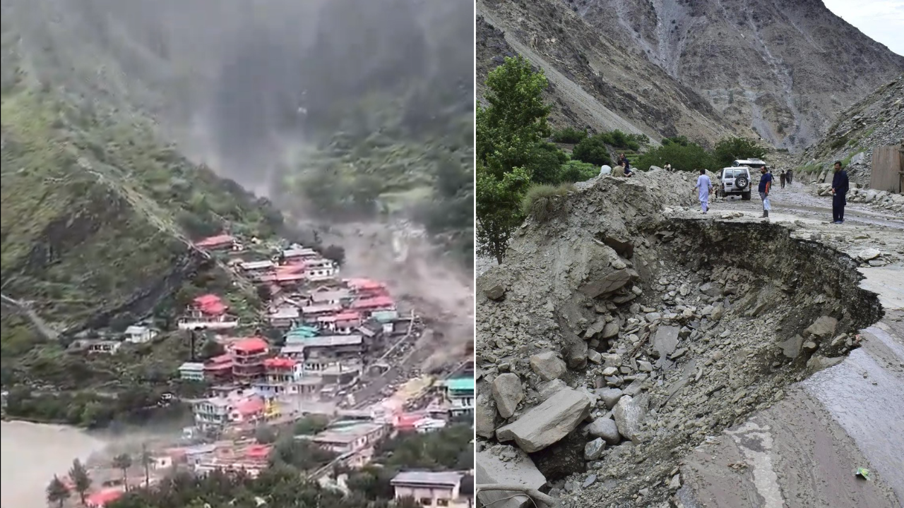
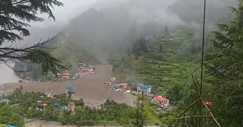
On August 5, 2025, disaster struck. Reports indicate that a sudden and powerful cloudburst in the catchment area of the Kheer Ganga river unleashed torrents of water upon Dharali village—just 4 km from the Indian Army’s Harsil base. Angry currents of debris, silt, and debris tore through guesthouses, shops, marketplaces, and roads in an instant.
Eyewitnesses describe the violence vividly. A priest from nearby Mukhba village filmed a 60-foot wall of mud and debris descending upon Dharali and called it “three minutes of pure hell.”. ISRO imagery later confirmed that the Bhagirathi River’s course shifted dramatically, reverting toward its historical path—signaling possible long-term geomorphic changes.
2. The Relief Begins: Multi-agency Mobilization
In response, an extensive relief operation kicked off, involving:
- The SDRF, NDRF, Indian Army, ITBP, and local police.
- The state government under CM Pushkar Singh Dhami declared war-footing relief operations; PM Modi and the Union Home Minister directed central support.
- Over 200 personnel deployed, including rescue teams, medics, engineers, and specialized equipment.
- Use of sniffer dogs, thermal scanners, and cadaver dogs for locating survivors and victims beneath the rubble.
3. Access Severed: Roads Washed Away, Isolation Sets In
One immediate and pressing challenge was logistics. Critical roads connecting Dharali to Harsil, Gangotri, and Uttarkashi were washed away—isolating the area and rendering vehicular movement impossible.
Rescue teams found themselves stranded. Over 163 roads statewide were blocked due to landslides and erosion. In response, a combination of air, animal, and engineering methods had to be adopted to restore access and transport supplies.
4. Drone Surveillance Takes Center Stage
In this scenario of fragmented access, the SDRF deployed drone surveillance over the flood-affected Kheer Ganga Ghat—a critical strategic move.
These drones provide:
- Aerial mapping of unstable terrain, crucial for accident-prone zones where landslides and floods constantly shift terrain boundaries.
- Real-time monitoring, aiding teams in pinpointing areas with missing persons or structural threats.
- Ground Penetration Radar (GPR) integration helps locate bodies or survivors beneath debris.
- Faster, safer assessments, even when roads are blocked.
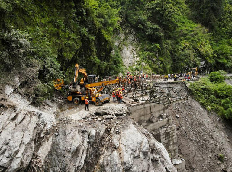
5. Logistics Adaptations: Helicopters, Bridges, Animals
With roads cut off, authorities improvised:
- Helicopter airlifts (Chinook, Mi-17, ALH, and civil copters) became lifelines for rescue and relief operations.
- Bailey bridge construction at Limchigadh (over the washed-away Limchigadh bridge) progressed rapidly to restore road connectivity.
- Horses and mules were employed to transport supplies where vehicles couldn’t traverse.
- MILs (like signal brigades) restored critical communication lines—enabling stranded locals to connect with relatives.
6. Ground Search and Rescue: Sensitive and Treacherous
SDRF and allied teams focused on thorough search operations:
- Evacuation of over 1,000 individuals in early days, including tourists and locals.
- Over 600 evacuees air-lifted.
- 4–5 deaths confirmed, with dozens clinically missing; locals sometimes estimating more buried beneath debris.
- Medical aid, temporary shelters, community kitchens, and trauma teams were mobilized.
7. Climatic and Environmental Concerns
Experts attribute this disaster not just to heavy rain but structural fragility:
- Landslides, cloudbursts, and even glacial lake outburst floods (GLOFs) are under investigation as triggers.
- Environmentalists argue that untamed construction and tourism-driven development in the fragile Bhagirathi eco-sensitive zone exacerbated the calamity.
- ISRO imagery shows the river’s course rewinding to a historical path—prompting long-term erosion concerns downstream.
8. Human Stories & Local Anguish
Amid the disaster emerged human pain and frustration:
- A priest’s video vividly capturing the 60-foot wall of sludge became a sobering eyewitness account of the disaster’s speed and fury.
- Locals expressed horror and despair—one resident shared: “Everything from hotels to markets has been destroyed… I haven’t witnessed a disaster like this before.”.
- Survivors criticized rescue slowdowns, noting that tourists were sometimes prioritized over villagers—though SDRF officials refuted this alleged bias.
- Across India, multiple states (e.g., Gujarat) coordinated to rescue stranded tourists—99 from Ahmedabad, 15 from Bhavnagar, and others.
9. Looking Ahead: Challenges and Resilience
Short-term focus areas:
- Complete the Bailey bridge and reopen roads for sustained relief movement.
- Continue drone and ground searches to recover missing persons safely.
- Maintain air corridors for aid, especially with fresh rainfall alerts.
- Ensure mental health and counseling for survivors amid collective trauma.
Long-term needs:
- Reinforce eco-sensitive regulations: Prevent speculative construction in vulnerable zones.
- Improve early-warning systems for cloudbursts and glacial threats.
- Strengthen inter-agency preparedness, including smart tech like drones, GPRs, and rapid bridge deployment.
- Focus on community education and resilient infrastructure, especially in pilgrimage and tourism routes.
Conclusion
The flash flood in Dharali near Kheer Ganga Ghat remains a tragic reminder of nature’s raw power, Earth’s changing fragility, and the urgent need for adaptive resilience. The SDRF’s drone surveillance is proving invaluable—enabling real-time insights where roads fail and uncertainty reigns.
But true resilience springs not just from technology or rescue campaigns—it comes from the combination of preparedness, preservation, empathy, and inclusive planning for vulnerable communities.
Read more latest news


https://shorturl.fm/UGXRV