Iran Vs Israel: See the Scene of Devastation in Satellite Images!
Introduction: War in the Shadows, Destruction in the Open
Iran vs Israel The Middle East, a region often engulfed in flames of history and ideology, has once again become the epicenter of global tension. The world watched with bated breath as two regional powerhouses—Iran and Israel—locked horns in what is now being termed the most sophisticated and high-impact shadow war in recent times.
For decades, both nations have been engaged in a cold war-like state. But the latest strikes, allegedly carried out by Israel on Iran’s nuclear and military infrastructure, followed by Iran’s counteroffensive involving over 100 missiles, have escalated tensions to a boiling point. This isn’t just about ground reports or diplomatic claims anymore—satellite images tell the truth.
In this blog, we explore the devastation caused, examine high-resolution satellite images, analyze the tactical significance of the targeted areas, and decode the geopolitical impact of this intensifying conflict.
1. The Escalation: A Timeline of Retaliation
While skirmishes between Iran and Israel have been covert for decades—spanning cyberattacks, proxy warfare, and intelligence sabotage—the recent days have witnessed a direct confrontation.
- Week 1: Israel allegedly launches precision airstrikes on Iranian nuclear and military bases near Natanz, Isfahan, and Parchin.
- Week 2: In retaliation, Iran fires over 100 ballistic and cruise missiles toward southern Israel, triggering widespread air raid sirens across Tel Aviv, Beersheba, and Dimona.
- Week 3: Both sides suffer casualties, but much remains classified—until now.
It was only when satellite images emerged via independent international platforms that the real scale of devastation became visible.
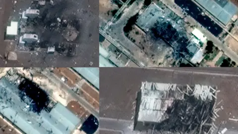
2. Satellite Images Reveal the Damage
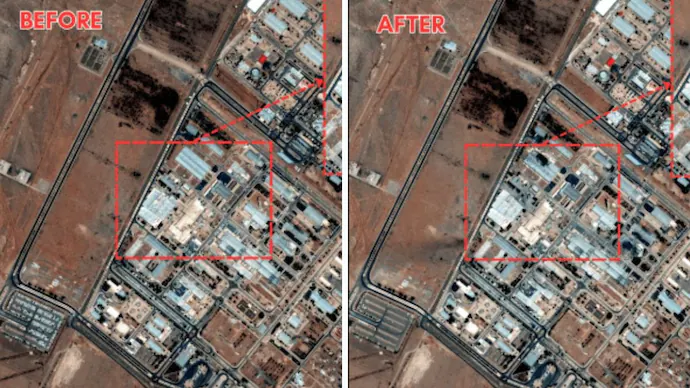
📍 Natanz Nuclear Facility (Iran)
Before: The facility showed standard reinforced bunkers and anti-air defenses.
After: Satellite imagery captured by commercial providers like Maxar Technologies revealed:
- Three major craters visible in the outer containment zones.
- Charred debris scattered over 300 meters.
- Collapse of a newly constructed subterranean section, likely hit by a bunker-busting bomb.
📍 Parchin Military Complex
This site, long suspected by Western agencies of hosting missile and explosive testing labs, showed:
- Severe structural collapse of two adjoining buildings.
- Thermal imaging confirms intense heat signatures, suggesting the use of thermobaric munitions.
- Activity ceased post-strike—no vehicular movement detected.
📍 Dimona, Israel
Iran’s retaliatory strike targeted the periphery of Israel’s controversial nuclear research facility:
- Anti-air systems active, but satellite footage shows three impact points near Negev desert installations.
- Limited visible infrastructure damage, but plumes of smoke suggest fuel or equipment depots may have been hit.
- Israeli Iron Dome and David’s Sling reportedly intercepted 80% of incoming missiles, but not all.
3. The Role of Intelligence and Drones
According to defense analysts, Mossad (Israel’s intelligence agency) had already infiltrated Iran’s high-security zones, establishing covert drone networks weeks in advance. Reports confirm:
- Explosive-laden drones were used to target key installations.
- Mossad had placed beacons for laser-guided munitions to lock in accurately.
- Iranian military sources admitted “external elements exploited internal vulnerabilities.”
This battle has shown that the war is as much about bytes and bots as it is about bullets and bombs.
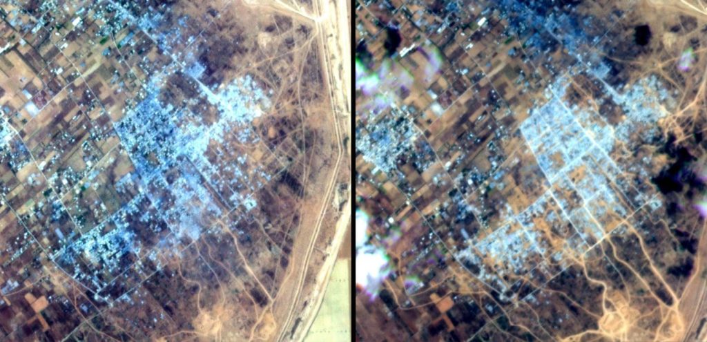
4. Civilian Impact Captured From Space
What makes this conflict particularly heart-wrenching is the collateral civilian damage, visible even from satellites.
- In Kermanshah and Yazd, Iranian cities near military zones, schools and homes were damaged.
- In Ashkelon and Sderot, Israeli border towns, satellite images showed scorched apartment complexes, collapsed roofs, and emergency tents.
- Displacement: UNOSAT estimates 30,000+ displaced civilians in Iran alone.
Imagery from the European Space Agency shows glowing red heat zones in urban pockets—evidence of uncontrolled fires and explosions in civilian zones.
5. Tactical Gains or Diplomatic Losses?
Experts are split. Some believe Israel’s attacks severely delayed Iran’s nuclear capabilities by at least 6 months. Others say Iran’s retaliation showed it’s not as fragile as assumed.
✅ Tactical Achievements (Israel):
- Neutralized several key uranium enrichment centrifuges.
- Destroyed top-secret underground bunkers used for drone and missile R&D.
✅ Tactical Achievements (Iran):
- Demonstrated missile reach across southern Israel.
- Forced global attention to regional instability.
But diplomatic losses are mounting for both:
- UN Security Council emergency session condemned the escalation.
- Oil prices surged, and India, China, and the EU called for immediate de-escalation.
- The US maintained strategic silence, adding to the tension.
6. What Global Powers Are Saying
🇺🇸 United States:
“We urge restraint. The situation is volatile and has the potential to spiral out of control.”
— State Department
🇷🇺 Russia:
“Israel must not endanger the region with provocative military acts. Iran has the right to defend its sovereignty.”
🇨🇳 China:
“We call for peace and multilateral dialogue. Both sides must step back.”
Interestingly, Turkey and Saudi Arabia, long skeptical of Iran, did not condemn Israel outright, showing subtle shifts in regional alliances.
7. Future Flashpoints to Watch
With satellite reconnaissance exposing destroyed missile silos, drone factories, and communication towers, the world waits to see the next move. Strategic analysts warn:
- Iran could activate proxy networks in Syria, Lebanon (Hezbollah), and Iraq.
- Israel may plan more cyber attacks—their “Stuxnet 2.0” cyberwarfare is reportedly ready.
- US and NATO could get indirectly pulled in if Israel’s defense base in the Golan Heights is hit.
8. The Technology Behind the Eyes in the Sky
Let’s not forget the role of satellite tech in shaping the narrative:
- Maxar, Planet Labs, and ESA Sentinel satellites have changed how wars are reported.
- Publicly available satellite images have outpaced military statements.
- Journalists, researchers, and even the public can now verify ground truths in real-time.
This has helped hold both Iran and Israel accountable in the global court of public opinion.
9. Israel’s Defense: Success or Stress Test?
Israel activated multiple layers of its defense:
- Iron Dome: Intercepted short-range rockets.
- David’s Sling: Handled medium-range threats.
- Arrow 3: Deployed for long-range ballistic missiles.
Though 80% interception was achieved, the remaining 20% impact zone has raised questions about system overload in case of a wider war.
10. Conclusion: Images That the World Cannot Ignore
War leaves behind smoke, stories, and scars. But in this age, it also leaves behind pixels—satellite images that capture not just damage but also the dignity and desperation of those caught in the crossfire.
The Iran-Israel confrontation is no longer shrouded in secrecy. Thanks to satellite imagery, the world has seen the truth with its own eyes—craters in nuclear sites, scorched airbases, damaged homes, and emergency tents.
Both nations may claim tactical superiority, but in the end, it’s the common people—visible as tiny specks amid vast devastation—who suffer the most.
read more latest news